
Fact No. 2.
“Armenia” is one of the most ancient place-names on Earth.
Although the various civilisations of ancient Mesopotamia have receded into the historical backdrop, their influence survives to this day. Cartography, or map-making, was just one of the many fields that was pioneered between the Tigris and the Euphrates all those millennia ago.
And one of the most ancient maps of the world (well, for us today, a map of the Near East or the Middle East) was carved out in clay, attributed to the Babylonians of the 6th century BC. It includes the land of “Urartu” or “Urashtu”, which was the Babylonian word for what the ancient Persians referred to as “Armina”, known more famously later – and to this day – as “Armenia”.
The Kingdom of Urartu or Ararat lasted from the 9th to the 6th century BC, during the course of which it competed against Assyrians and Babylonians, as well as Medians and other ancient Persians. It is considered to be the pre-cursor of the ancient Armenian kingdoms. Centred around Mount Ararat – and that mountain remains a strong symbol for Armenians – the capital of Urartu is oftentimes referred to as the first Armenian capital. The fortress of Tushpa still towers above the city of Van, in eastern Turkey – a city that has one of the longest records in the world of being continuously inhabited, and certainly a city with a most ancient Armenian population until 1915.
The modern Armenian capital, Yerevan, also has a pedigree from Urartu. Archaeological work in the 1950s brought to light the fortress of Erebuni, established on what is part of Yerevan today by King Argishti I in 782 BC, according to inscriptions found during excavations. The king’s declaration, carved onto stone in the cuneiform script of Mesopotamia, is considered to be Yerevan’s “birth certificate”, the name “Yerevan” itself being derived from “Erebuni” by the same token. The year 1968 was marked with wide-spread celebrations of the 2,750th anniversary of the founding of the fortress, and days dedicated to the Yerevan-Erebuni story continue to be held with annual public events in the country.

The Kingdom of Urartu, 9th-6th centuries BC
Artaxiad, Creative Commons
References and Other Resources
1. Kurt Buzard. “Babylonian World Map, British Museum, London”, Travel to Eat, October 9, 2012
2. The British Museum. “Map of the World”
3. Rouben Galichian. Historic Maps of Armenia: The Cartographic Heritage. I. B. Tauris, 2004
4. Jona Lendering. “Urartu”, Livius.Org, October 12, 2011
5. Wikipedia: “Babylonian Map of the World”
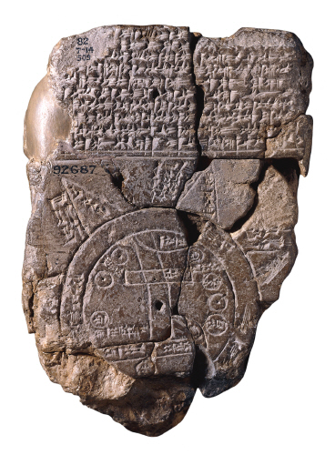
Image Caption
The Babylonian clay tablet map, discovered in the late 19th century.
Attribution and Source
The British Museum. “The Map of the World” via Wikimedia Commons.
Follow us on
Recent Facts
Fact No. 100
…and the Armenian people continue to remember and to...
Fact No. 99
…as minorities in Turkey are often limited in their expression…
Fact No. 98
Armenians continue to live in Turkey…
Fact No. 97
The world’s longest aerial tramway opened in Armenia in 2010